 The outline of Chuck and Annie Goldmark with their sons Colin, 10, on the left and Derek, 12, on the right are shown in bas-relief.
Thursday, November 26, 2009
Goldmark Overlook Plaque
 The outline of Chuck and Annie Goldmark with their sons Colin, 10, on the left and Derek, 12, on the right are shown in bas-relief.
Mt. Rainer, Goldmark Overlook
This Mount Rainier from the Goldmark Family Overlook at the foot of Madrona Drive on the west shore of Lake Washington, Seattle. Chuck, Annie, Colin and Derek Goldmark were my dearest of friends. They were murdered at their home in Seattle overlooking Lake Washington with Mount Rainier in the not so far distance on Christmas Eve, 1985. Not a day goes by when I do not think of them.
Sunday, November 15, 2009
Walla Walla, Blue Mountains
 This is a picture of the Blue Mountains of Washington and Oregon east and southerly of Walla Walla, Washington. It is early November. In two weeks time these mountains were covered with snow.
Walla Walla Airport Wineries

November 2009 -- Walla Walla has become known for its vineyards and wineries. The wineries are located throughout the area away from the vineyards. Many of them are located at the Walla Walla Airport port district. This picture is of one of the wineries locations at the airport. There are many others spread thoughout this large airport area.
The airport was created during WW II. Many of the original buildings have been preserved.
Monday, October 19, 2009
Bring Back the Canopy
Sunday, September 27, 2009
Seattle, Early Fall 2009
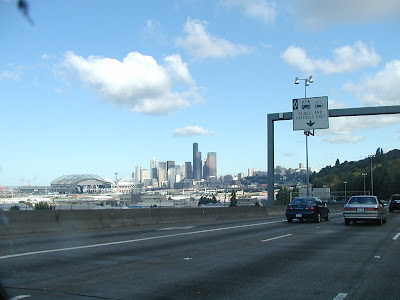
It is a Saturday in September 2009. This is Seattle from the I-5 freeway heading north. No accidents so the traffic is moving at a good clip.
In about 5 years the US 99 tunnel will have been built taking north south traffic parallel and west of I-5 along the Puget Sound shore. It will reduce some of the traffic delays on I-5. One never really knows whether a new highway is a solution -- if you build it it will fill to capacity very soon and will probably go over capacity because of the influx of people to the Eastern Puget Sound Region. In the future there will be a solid residential metropolitan area from Portland, Oregon to Vancouver, British Columbia.
In about 5 years the US 99 tunnel will have been built taking north south traffic parallel and west of I-5 along the Puget Sound shore. It will reduce some of the traffic delays on I-5. One never really knows whether a new highway is a solution -- if you build it it will fill to capacity very soon and will probably go over capacity because of the influx of people to the Eastern Puget Sound Region. In the future there will be a solid residential metropolitan area from Portland, Oregon to Vancouver, British Columbia.
Tuesday, September 15, 2009
I See You Too
The grain has been harvested. The deer are welcome in the fields. This beautiful doe felt safe. She was over 300 feet away from me, and I like to think she knows me from my numerous travels through her home fields and forest.
Supper Time
Sunday, September 6, 2009
An Old Road
Friday, September 4, 2009
Ione - Metaline Road Circa 1920
Afternoon Clouds Forming
Monday, August 17, 2009
Protest
Friday, August 14, 2009
Sacred Heart on the South Hill
This is an August 2009 view of Sacred Heart Hospital on the north side of Spokane's "South Hill." I am standing at the edge of the rimrock west of the city limits.
Rimrock on a cloudy day in August
Friday, August 7, 2009
Monday, August 3, 2009
Road Crosses
Saturday, August 1, 2009
Latah Creek
Wednesday, June 17, 2009
Tuesday, June 9, 2009
Lincoln County Wheat Growers not Captives of Harvest Markets
Monday, June 8, 2009
The Swanson Lakes Public School north of Swanson Lakes, Washington. The school was built circa 1910. This picture was taken in late May, 2009. Water is still in the lakes. This area was known as place where the horses, mules and donkeys used in the construction of railroads and other roads wintered. It may seem stark, but all one has to do is to spend a few hours in the area and then he or she will realize how alive and even mystical this place is. You have to have a welcoming soul to see it, but when you do you will know.

Thursday, May 28, 2009
Wednesday, May 27, 2009
The Wilbur, Washington Cemetary
Subscribe to:
Comments (Atom)
About Me

- Steve Eugster
- Lawyer, former Spokane City Council member, public trust advocate, author and advocate of Spokane's "strong Mayor" form of government.


